|
|
|||||||||||||||||
| Point ID: 5140 | Downloads | Plots | Site Data | Code: 03ED004 |
|
|
|||||||||||||||||
| Download | |
|---|---|
| Site Descriptor Information | Site Time Series Data |
| Link to all available data | |
| View: | Time Series | All |
| Units: | m3/s |
| Statistic | Jan | Feb | Mar | Apr | May | Jun | Jul | Aug | Sep | Oct | Nov | Dec | Annual |
|---|---|---|---|---|---|---|---|---|---|---|---|---|---|
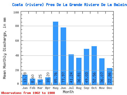
| Mean | 13.78 | 8.67 | 7.25 | 10.20 | 85.75 | 77.97 | 41.23 | 36.80 | 49.03 | 52.55 | 36.07 | 22.85 | 442.17 |
| Standard Deviation | 2.95 | 1.49 | 1.38 | 6.65 | 29.97 | 29.77 | 14.35 | 14.43 | 16.46 | 17.53 | 9.69 | 5.88 | 59.34 |
| Min | 8.06 | 4.99 | 4.71 | 4.34 | 33.88 | 34.89 | 23.29 | 16.92 | 24.89 | 27.30 | 20.86 | 16.22 | 356.06 |
| Max | 21.00 | 11.83 | 10.08 | 30.05 | 168.85 | 154.17 | 83.14 | 72.47 | 80.82 | 99.32 | 64.80 | 37.52 | 559.27 |
| Coefficient of Variation | 0.21 | 0.17 | 0.19 | 0.65 | 0.35 | 0.38 | 0.35 | 0.39 | 0.34 | 0.33 | 0.27 | 0.26 | 0.13 |
 Return to R-Arctic Net Home Page