|
|
|||||||||||||||||
| Point ID: 5111 | Downloads | Plots | Site Data | Code: 03DA002 |
|
|
|||||||||||||||||
| Download | |
|---|---|
| Site Descriptor Information | Site Time Series Data |
| Link to all available data | |
| View: | Time Series | All |
| Units: | mm |
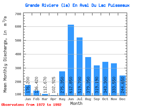
| Statistic | Jan | Feb | Mar | Apr | May | Jun | Jul | Aug | Sep | Oct | Nov | Dec | Annual |
|---|---|---|---|---|---|---|---|---|---|---|---|---|---|
| Mean | 176.20 | 136.42 | 112.67 | 102.92 | 275.35 | 612.85 | 519.70 | 379.35 | 319.19 | 343.30 | 333.55 | 244.65 | 294.99 |
| Standard Deviation | 31.74 | 21.00 | 15.30 | 13.91 | 108.01 | 112.81 | 118.97 | 122.95 | 113.97 | 100.09 | 105.18 | 56.41 | 51.63 |
| Min | 103.00 | 97.40 | 90.80 | 79.00 | 123.00 | 414.00 | 303.00 | 171.00 | 151.00 | 140.00 | 134.00 | 115.00 | 215.50 |
| Max | 238.00 | 168.00 | 138.00 | 125.00 | 513.00 | 793.00 | 707.00 | 697.00 | 620.00 | 500.00 | 656.00 | 392.00 | 383.42 |
| Coefficient of Variation | 0.18 | 0.15 | 0.14 | 0.14 | 0.39 | 0.18 | 0.23 | 0.32 | 0.36 | 0.29 | 0.32 | 0.23 | 0.17 |
 Return to R-Arctic Net Home Page