|
|
|||||||||||||||||
| Point ID: 5111 | Downloads | Plots | Site Data | Code: 03DA002 |
|
|
|||||||||||||||||
| Download | |
|---|---|
| Site Descriptor Information | Site Time Series Data |
| Link to all available data | |
| View: | Time Series | All |
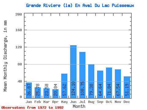
| Units: | m3/s |
| Statistic | Jan | Feb | Mar | Apr | May | Jun | Jul | Aug | Sep | Oct | Nov | Dec | Annual |
|---|---|---|---|---|---|---|---|---|---|---|---|---|---|
| Mean | 36.86 | 26.00 | 23.57 | 20.84 | 57.61 | 124.10 | 108.73 | 79.37 | 64.64 | 71.83 | 67.54 | 51.19 | 727.33 |
| Standard Deviation | 6.64 | 4.00 | 3.20 | 2.82 | 22.60 | 22.84 | 24.89 | 25.72 | 23.08 | 20.94 | 21.30 | 11.80 | 127.30 |
| Min | 21.55 | 18.57 | 19.00 | 16.00 | 25.73 | 83.83 | 63.39 | 35.78 | 30.58 | 29.29 | 27.14 | 24.06 | 531.34 |
| Max | 49.79 | 32.02 | 28.87 | 25.31 | 107.33 | 160.58 | 147.92 | 145.82 | 125.55 | 104.61 | 132.84 | 82.01 | 945.36 |
| Coefficient of Variation | 0.18 | 0.15 | 0.14 | 0.14 | 0.39 | 0.18 | 0.23 | 0.32 | 0.36 | 0.29 | 0.32 | 0.23 | 0.17 |
 Return to R-Arctic Net Home Page