|
|
|||||||||||||||||
| Point ID: 5103 | Downloads | Plots | Site Data | Code: 03CB002 |
|
|
|||||||||||||||||
| Download | |
|---|---|
| Site Descriptor Information | Site Time Series Data |
| Link to all available data | |
| View: | Time Series | All |
| Units: | mm |
| Statistic | Jan | Feb | Mar | Apr | May | Jun | Jul | Aug | Sep | Oct | Nov | Dec | Annual |
|---|---|---|---|---|---|---|---|---|---|---|---|---|---|
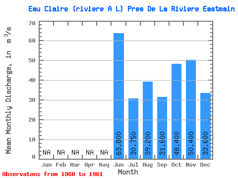
| Mean | 63.80 | 30.75 | 39.20 | 31.60 | 48.40 | 50.40 | 33.60 | ||||||
| Standard Deviation | 5.45 | ||||||||||||
| Min | 63.80 | 26.90 | 39.20 | 31.60 | 48.40 | 50.40 | 33.60 | ||||||
| Max | 63.80 | 34.60 | 39.20 | 31.60 | 48.40 | 50.40 | 33.60 | ||||||
| Coefficient of Variation | 0.18 |
 Return to R-Arctic Net Home Page