|
|
| Point ID: 5103 | Downloads | Plots | Site Data | Code: 03CB002 |
|
| Download | |
|---|---|
| Site Descriptor Information | Site Time Series Data |
| Link to all available data | |
|
|
|
| View: | Statistics | All |
| Units: | mm |
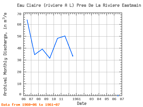
| Year | Jan | Feb | Mar | Apr | May | Jun | Jul | Aug | Sep | Oct | Nov | Dec | Annual | 1960 | 63.80 | 34.60 | 39.20 | 31.60 | 48.40 | 50.40 | 33.60 | 1961 | 26.90 |
|---|
 Return to R-Arctic Net Home Page