|
|
|||||||||||||||||
| Point ID: 506 | Downloads | Plots | Site Data | Code: 05EC003 |
|
|
|||||||||||||||||
| Download | |
|---|---|
| Site Descriptor Information | Site Time Series Data |
| Link to all available data | |
| View: | Time Series | All |
| Units: | mm |
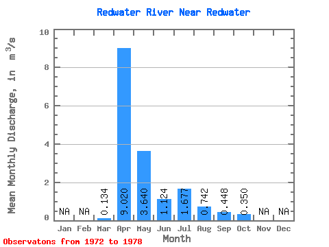
| Statistic | Jan | Feb | Mar | Apr | May | Jun | Jul | Aug | Sep | Oct | Nov | Dec | Annual |
|---|---|---|---|---|---|---|---|---|---|---|---|---|---|
| Mean | 0.13 | 9.02 | 3.64 | 1.12 | 1.68 | 0.74 | 0.45 | 0.35 | |||||
| Standard Deviation | 0.06 | 11.53 | 4.97 | 1.15 | 2.94 | 0.49 | 0.41 | 0.26 | |||||
| Min | 0.06 | 2.51 | 0.65 | 0.24 | 0.21 | 0.18 | 0.04 | 0.02 | |||||
| Max | 0.21 | 32.40 | 13.70 | 3.07 | 7.65 | 1.55 | 1.21 | 0.69 | |||||
| Coefficient of Variation | 0.47 | 1.28 | 1.37 | 1.02 | 1.76 | 0.66 | 0.91 | 0.75 |
 Return to R-Arctic Net Home Page