|
|
|||||||||||||||||
| Point ID: 506 | Downloads | Plots | Site Data | Code: 05EC003 |
|
|
|||||||||||||||||
| Download | |
|---|---|
| Site Descriptor Information | Site Time Series Data |
| Link to all available data | |
| View: | Time Series | All |
| Units: | m3/s |
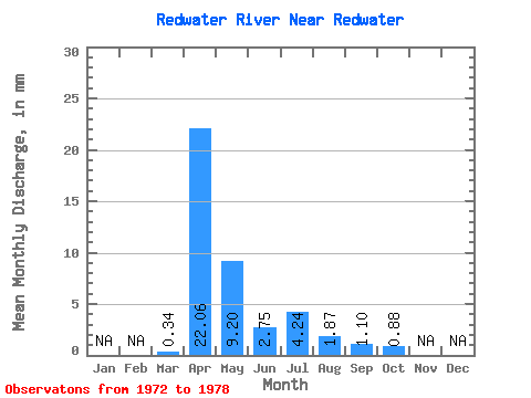
| Statistic | Jan | Feb | Mar | Apr | May | Jun | Jul | Aug | Sep | Oct | Nov | Dec | Annual |
|---|---|---|---|---|---|---|---|---|---|---|---|---|---|
| Mean | 0.24 | 15.69 | 6.54 | 1.96 | 3.01 | 1.33 | 0.78 | 0.63 | |||||
| Standard Deviation | 0.11 | 20.07 | 8.94 | 2.00 | 5.29 | 0.88 | 0.71 | 0.47 | |||||
| Min | 0.10 | 4.37 | 1.17 | 0.42 | 0.37 | 0.32 | 0.07 | 0.04 | |||||
| Max | 0.39 | 56.36 | 24.62 | 5.34 | 13.75 | 2.79 | 2.10 | 1.23 | |||||
| Coefficient of Variation | 0.47 | 1.28 | 1.37 | 1.02 | 1.76 | 0.66 | 0.91 | 0.75 |
 Return to R-Arctic Net Home Page