|
|
|||||||||||||||||
| Point ID: 493 | Downloads | Plots | Site Data | Code: 05EA005 |
|
|
|||||||||||||||||
| Download | |
|---|---|
| Site Descriptor Information | Site Time Series Data |
| Link to all available data | |
| View: | Time Series | All |
| Units: | mm |
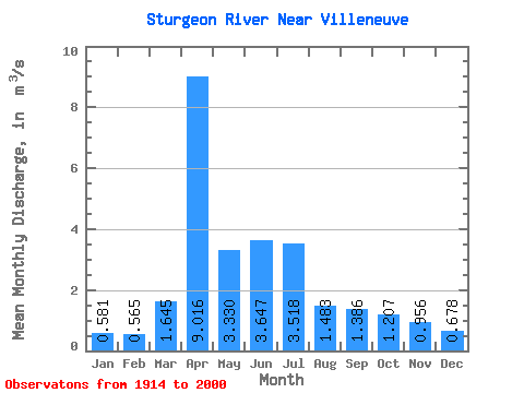
| Statistic | Jan | Feb | Mar | Apr | May | Jun | Jul | Aug | Sep | Oct | Nov | Dec | Annual |
|---|---|---|---|---|---|---|---|---|---|---|---|---|---|
| Mean | 0.58 | 0.56 | 1.65 | 9.02 | 3.33 | 3.65 | 3.52 | 1.48 | 1.39 | 1.21 | 0.96 | 0.68 | 2.28 |
| Standard Deviation | 0.61 | 0.50 | 2.25 | 9.94 | 4.65 | 5.62 | 5.43 | 1.38 | 1.46 | 1.49 | 1.28 | 0.81 | 2.18 |
| Min | 0.01 | 0.01 | 0.05 | 0.24 | 0.00 | 0.00 | 0.00 | 0.00 | 0.00 | 0.00 | 0.05 | 0.05 | 0.13 |
| Max | 2.24 | 1.85 | 9.91 | 44.50 | 25.50 | 22.60 | 28.80 | 5.64 | 6.30 | 6.48 | 6.33 | 3.30 | 10.42 |
| Coefficient of Variation | 1.06 | 0.89 | 1.36 | 1.10 | 1.40 | 1.54 | 1.54 | 0.93 | 1.05 | 1.24 | 1.33 | 1.20 | 0.95 |
 Return to R-Arctic Net Home Page