|
|
|||||||||||||||||
| Point ID: 493 | Downloads | Plots | Site Data | Code: 05EA005 |
|
|
|||||||||||||||||
| Download | |
|---|---|
| Site Descriptor Information | Site Time Series Data |
| Link to all available data | |
| View: | Time Series | All |
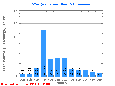
| Units: | m3/s |
| Statistic | Jan | Feb | Mar | Apr | May | Jun | Jul | Aug | Sep | Oct | Nov | Dec | Annual |
|---|---|---|---|---|---|---|---|---|---|---|---|---|---|
| Mean | 0.81 | 0.72 | 2.31 | 12.23 | 4.67 | 4.95 | 4.93 | 2.08 | 1.88 | 1.69 | 1.30 | 0.95 | 37.66 |
| Standard Deviation | 0.86 | 0.64 | 3.15 | 13.49 | 6.52 | 7.62 | 7.61 | 1.94 | 1.98 | 2.09 | 1.73 | 1.14 | 35.96 |
| Min | 0.01 | 0.01 | 0.07 | 0.33 | 0.00 | 0.00 | 0.00 | 0.00 | 0.00 | 0.00 | 0.07 | 0.07 | 2.22 |
| Max | 3.14 | 2.36 | 13.89 | 60.39 | 35.75 | 30.67 | 40.38 | 7.91 | 8.55 | 9.09 | 8.59 | 4.63 | 172.19 |
| Coefficient of Variation | 1.06 | 0.89 | 1.36 | 1.10 | 1.40 | 1.54 | 1.54 | 0.93 | 1.05 | 1.24 | 1.33 | 1.20 | 0.95 |
 Return to R-Arctic Net Home Page