|
|
|||||||||||||||||
| Point ID: 49 | Downloads | Plots | Site Data | Code: 05AB031 |
|
|
|||||||||||||||||
| Download | |
|---|---|
| Site Descriptor Information | Site Time Series Data |
| Link to all available data | |
| View: | Time Series | All |
| Units: | mm |
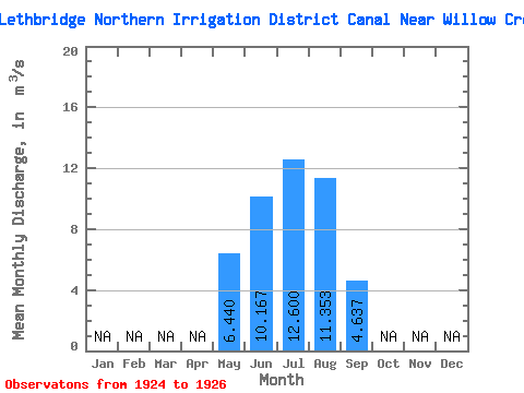
| Statistic | Jan | Feb | Mar | Apr | May | Jun | Jul | Aug | Sep | Oct | Nov | Dec | Annual |
|---|---|---|---|---|---|---|---|---|---|---|---|---|---|
| Mean | 6.44 | 10.17 | 12.60 | 11.35 | 4.64 | ||||||||
| Standard Deviation | 2.38 | 1.67 | 1.10 | 3.87 | 0.62 | ||||||||
| Min | 4.17 | 9.18 | 11.50 | 8.73 | 4.05 | ||||||||
| Max | 8.91 | 12.10 | 13.70 | 15.80 | 5.29 | ||||||||
| Coefficient of Variation | 0.37 | 0.17 | 0.09 | 0.34 | 0.13 |
 Return to R-Arctic Net Home Page