|
|
| Point ID: 49 | Downloads | Plots | Site Data | Code: 05AB031 |
|
| Download | |
|---|---|
| Site Descriptor Information | Site Time Series Data |
| Link to all available data | |
|
|
|
| View: | Statistics | All |
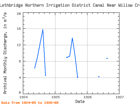
| Units: | mm |
| Year | Jan | Feb | Mar | Apr | May | Jun | Jul | Aug | Sep | Oct | Nov | Dec | Annual | 1924 | 6.24 | 9.18 | 12.60 | 15.80 | 4.57 | 1925 | 8.91 | 9.22 | 13.70 | 9.53 | 4.05 | 1926 | 4.17 | 12.10 | 11.50 | 8.73 | 5.29 |
|---|
 Return to R-Arctic Net Home Page