|
|
|||||||||||||||||
| Point ID: 480 | Downloads | Plots | Site Data | Code: 05DE007 |
|
|
|||||||||||||||||
| Download | |
|---|---|
| Site Descriptor Information | Site Time Series Data |
| Link to all available data | |
| View: | Time Series | All |
| Units: | mm |
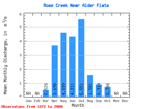
| Statistic | Jan | Feb | Mar | Apr | May | Jun | Jul | Aug | Sep | Oct | Nov | Dec | Annual |
|---|---|---|---|---|---|---|---|---|---|---|---|---|---|
| Mean | 0.53 | 3.70 | 4.60 | 4.31 | 5.55 | 1.58 | 0.91 | 0.75 | |||||
| Standard Deviation | 0.50 | 3.14 | 3.66 | 5.27 | 5.68 | 1.67 | 1.09 | 0.79 | |||||
| Min | 0.08 | 0.68 | 0.39 | 0.50 | 0.10 | 0.03 | 0.09 | 0.10 | |||||
| Max | 2.02 | 14.60 | 14.20 | 23.20 | 19.10 | 7.56 | 5.49 | 3.38 | |||||
| Coefficient of Variation | 0.95 | 0.85 | 0.80 | 1.22 | 1.02 | 1.06 | 1.19 | 1.06 |
 Return to R-Arctic Net Home Page