|
|
|||||||||||||||||
| Point ID: 480 | Downloads | Plots | Site Data | Code: 05DE007 |
|
|
|||||||||||||||||
| Download | |
|---|---|
| Site Descriptor Information | Site Time Series Data |
| Link to all available data | |
| View: | Time Series | All |
| Units: | m3/s |
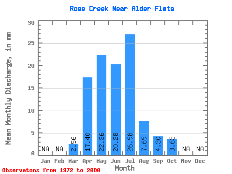
| Statistic | Jan | Feb | Mar | Apr | May | Jun | Jul | Aug | Sep | Oct | Nov | Dec | Annual |
|---|---|---|---|---|---|---|---|---|---|---|---|---|---|
| Mean | 2.56 | 17.40 | 22.35 | 20.28 | 26.98 | 7.68 | 4.30 | 3.62 | |||||
| Standard Deviation | 2.42 | 14.78 | 17.78 | 24.79 | 27.62 | 8.12 | 5.12 | 3.84 | |||||
| Min | 0.39 | 3.19 | 1.88 | 2.34 | 0.47 | 0.16 | 0.40 | 0.49 | |||||
| Max | 9.82 | 68.68 | 69.02 | 109.14 | 92.83 | 36.74 | 25.83 | 16.43 | |||||
| Coefficient of Variation | 0.95 | 0.85 | 0.80 | 1.22 | 1.02 | 1.06 | 1.19 | 1.06 |
 Return to R-Arctic Net Home Page