|
|
|||||||||||||||||
| Point ID: 475 | Downloads | Plots | Site Data | Code: 05DD008 |
|
|
|||||||||||||||||
| Download | |
|---|---|
| Site Descriptor Information | Site Time Series Data |
| Link to all available data | |
| View: | Time Series | All |
| Units: | mm |
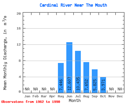
| Statistic | Jan | Feb | Mar | Apr | May | Jun | Jul | Aug | Sep | Oct | Nov | Dec | Annual |
|---|---|---|---|---|---|---|---|---|---|---|---|---|---|
| Mean | 7.45 | 12.61 | 10.44 | 7.65 | 5.83 | 3.97 | |||||||
| Standard Deviation | 3.17 | 8.29 | 5.62 | 4.95 | 3.42 | 2.00 | |||||||
| Min | 2.60 | 3.08 | 3.40 | 2.70 | 1.83 | 1.26 | |||||||
| Max | 14.90 | 34.60 | 23.30 | 21.30 | 14.20 | 9.13 | |||||||
| Coefficient of Variation | 0.43 | 0.66 | 0.54 | 0.65 | 0.59 | 0.50 |
 Return to R-Arctic Net Home Page