|
|
|||||||||||||||||
| Point ID: 475 | Downloads | Plots | Site Data | Code: 05DD008 |
|
|
|||||||||||||||||
| Download | |
|---|---|
| Site Descriptor Information | Site Time Series Data |
| Link to all available data | |
| View: | Time Series | All |
| Units: | m3/s |
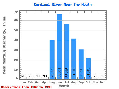
| Statistic | Jan | Feb | Mar | Apr | May | Jun | Jul | Aug | Sep | Oct | Nov | Dec | Annual |
|---|---|---|---|---|---|---|---|---|---|---|---|---|---|
| Mean | 40.29 | 66.02 | 56.45 | 41.40 | 30.50 | 21.48 | |||||||
| Standard Deviation | 17.18 | 43.43 | 30.38 | 26.75 | 17.91 | 10.84 | |||||||
| Min | 14.07 | 16.13 | 18.39 | 14.61 | 9.58 | 6.82 | |||||||
| Max | 80.61 | 181.18 | 126.06 | 115.23 | 74.36 | 49.39 | |||||||
| Coefficient of Variation | 0.43 | 0.66 | 0.54 | 0.65 | 0.59 | 0.50 |
 Return to R-Arctic Net Home Page