|
|
|||||||||||||||||
| Point ID: 473 | Downloads | Plots | Site Data | Code: 05DD005 |
|
|
|||||||||||||||||
| Download | |
|---|---|
| Site Descriptor Information | Site Time Series Data |
| Link to all available data | |
| View: | Time Series | All |
| Units: | mm |
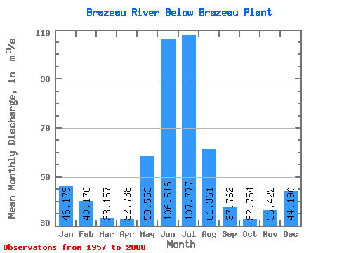
| Statistic | Jan | Feb | Mar | Apr | May | Jun | Jul | Aug | Sep | Oct | Nov | Dec | Annual |
|---|---|---|---|---|---|---|---|---|---|---|---|---|---|
| Mean | 46.18 | 40.18 | 33.16 | 32.74 | 58.55 | 106.52 | 107.78 | 61.36 | 37.76 | 32.75 | 36.42 | 44.19 | 52.15 |
| Standard Deviation | 10.39 | 10.81 | 15.23 | 12.94 | 27.87 | 61.54 | 57.81 | 37.34 | 21.18 | 19.14 | 11.65 | 8.01 | 12.19 |
| Min | 27.90 | 22.60 | 2.96 | 7.77 | 12.50 | 34.30 | 0.70 | 0.11 | 0.07 | 0.86 | 5.88 | 25.80 | 32.49 |
| Max | 62.60 | 63.90 | 77.30 | 60.30 | 149.00 | 263.00 | 243.00 | 159.00 | 90.20 | 79.80 | 65.30 | 61.30 | 84.58 |
| Coefficient of Variation | 0.23 | 0.27 | 0.46 | 0.40 | 0.48 | 0.58 | 0.54 | 0.61 | 0.56 | 0.58 | 0.32 | 0.18 | 0.23 |
 Return to R-Arctic Net Home Page