|
|
|||||||||||||||||
| Point ID: 473 | Downloads | Plots | Site Data | Code: 05DD005 |
|
|
|||||||||||||||||
| Download | |
|---|---|
| Site Descriptor Information | Site Time Series Data |
| Link to all available data | |
| View: | Time Series | All |
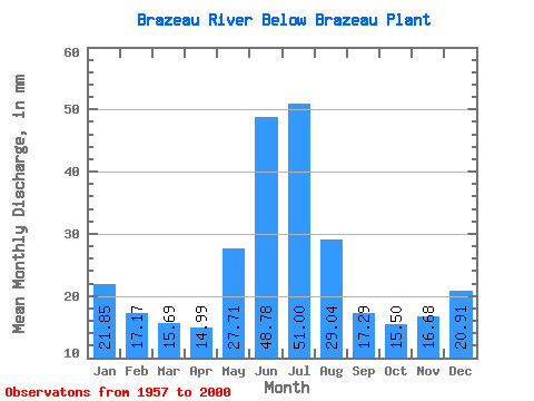
| Units: | m3/s |
| Statistic | Jan | Feb | Mar | Apr | May | Jun | Jul | Aug | Sep | Oct | Nov | Dec | Annual |
|---|---|---|---|---|---|---|---|---|---|---|---|---|---|
| Mean | 21.85 | 17.32 | 15.69 | 14.99 | 27.70 | 48.78 | 50.99 | 29.03 | 17.29 | 15.50 | 16.68 | 20.91 | 290.80 |
| Standard Deviation | 4.92 | 4.66 | 7.21 | 5.92 | 13.19 | 28.18 | 27.35 | 17.66 | 9.70 | 9.06 | 5.34 | 3.79 | 67.99 |
| Min | 13.20 | 9.74 | 1.40 | 3.56 | 5.91 | 15.71 | 0.33 | 0.05 | 0.03 | 0.41 | 2.69 | 12.21 | 181.19 |
| Max | 29.62 | 27.55 | 36.57 | 27.61 | 70.50 | 120.44 | 114.97 | 75.23 | 41.31 | 37.76 | 29.90 | 29.00 | 471.59 |
| Coefficient of Variation | 0.23 | 0.27 | 0.46 | 0.40 | 0.48 | 0.58 | 0.54 | 0.61 | 0.56 | 0.58 | 0.32 | 0.18 | 0.23 |
 Return to R-Arctic Net Home Page