|
|
|||||||||||||||||
| Point ID: 472 | Downloads | Plots | Site Data | Code: 05DD004 |
|
|
|||||||||||||||||
| Download | |
|---|---|
| Site Descriptor Information | Site Time Series Data |
| Link to all available data | |
| View: | Time Series | All |
| Units: | mm |
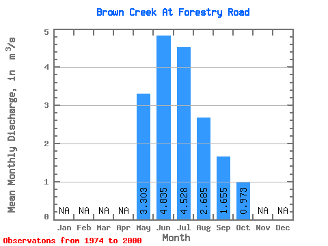
| Statistic | Jan | Feb | Mar | Apr | May | Jun | Jul | Aug | Sep | Oct | Nov | Dec | Annual |
|---|---|---|---|---|---|---|---|---|---|---|---|---|---|
| Mean | 3.30 | 4.83 | 4.53 | 2.69 | 1.66 | 0.97 | |||||||
| Standard Deviation | 1.65 | 3.52 | 4.02 | 2.37 | 1.26 | 0.56 | |||||||
| Min | 0.59 | 0.61 | 0.95 | 0.56 | 0.47 | 0.26 | |||||||
| Max | 7.12 | 17.80 | 18.30 | 9.70 | 5.09 | 2.71 | |||||||
| Coefficient of Variation | 0.50 | 0.73 | 0.89 | 0.88 | 0.76 | 0.57 |
 Return to R-Arctic Net Home Page