|
|
|||||||||||||||||
| Point ID: 472 | Downloads | Plots | Site Data | Code: 05DD004 |
|
|
|||||||||||||||||
| Download | |
|---|---|
| Site Descriptor Information | Site Time Series Data |
| Link to all available data | |
| View: | Time Series | All |
| Units: | m3/s |
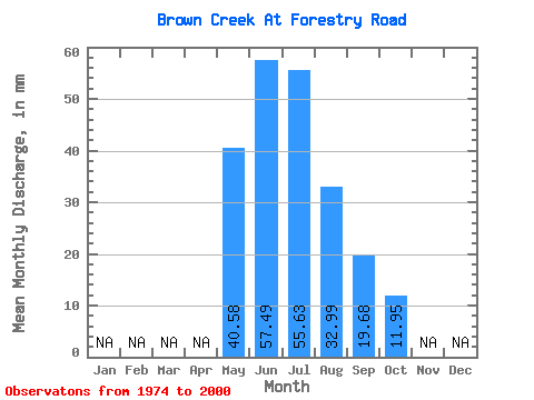
| Statistic | Jan | Feb | Mar | Apr | May | Jun | Jul | Aug | Sep | Oct | Nov | Dec | Annual |
|---|---|---|---|---|---|---|---|---|---|---|---|---|---|
| Mean | 40.57 | 57.49 | 55.63 | 32.98 | 19.68 | 11.95 | |||||||
| Standard Deviation | 20.24 | 41.80 | 49.36 | 29.16 | 14.99 | 6.81 | |||||||
| Min | 7.21 | 7.21 | 11.70 | 6.92 | 5.61 | 3.18 | |||||||
| Max | 87.47 | 211.64 | 224.81 | 119.16 | 60.52 | 33.29 | |||||||
| Coefficient of Variation | 0.50 | 0.73 | 0.89 | 0.88 | 0.76 | 0.57 |
 Return to R-Arctic Net Home Page