|
|
|||||||||||||||||
| Point ID: 466 | Downloads | Plots | Site Data | Code: 05DC010 |
|
|
|||||||||||||||||
| Download | |
|---|---|
| Site Descriptor Information | Site Time Series Data |
| Link to all available data | |
| View: | Time Series | All |
| Units: | mm |
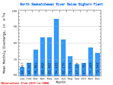
| Statistic | Jan | Feb | Mar | Apr | May | Jun | Jul | Aug | Sep | Oct | Nov | Dec | Annual |
|---|---|---|---|---|---|---|---|---|---|---|---|---|---|
| Mean | 65.37 | 68.01 | 75.98 | 83.45 | 83.45 | 94.63 | 82.17 | 71.97 | 67.11 | 67.75 | 77.29 | 73.94 | 76.40 |
| Standard Deviation | 12.55 | 17.92 | 16.02 | 18.38 | 24.61 | 24.79 | 31.98 | 29.36 | 24.63 | 19.94 | 15.21 | 16.43 | 8.65 |
| Min | 35.00 | 29.80 | 41.60 | 37.10 | 47.70 | 39.90 | 18.90 | 26.40 | 0.16 | 0.22 | 40.20 | 47.90 | 57.70 |
| Max | 83.90 | 104.00 | 107.00 | 121.00 | 146.00 | 155.00 | 153.00 | 136.00 | 115.00 | 112.00 | 105.00 | 102.00 | 99.08 |
| Coefficient of Variation | 0.19 | 0.26 | 0.21 | 0.22 | 0.29 | 0.26 | 0.39 | 0.41 | 0.37 | 0.29 | 0.20 | 0.22 | 0.11 |
 Return to R-Arctic Net Home Page