|
|
|||||||||||||||||
| Point ID: 466 | Downloads | Plots | Site Data | Code: 05DC010 |
|
|
|||||||||||||||||
| Download | |
|---|---|
| Site Descriptor Information | Site Time Series Data |
| Link to all available data | |
| View: | Time Series | All |
| Units: | m3/s |
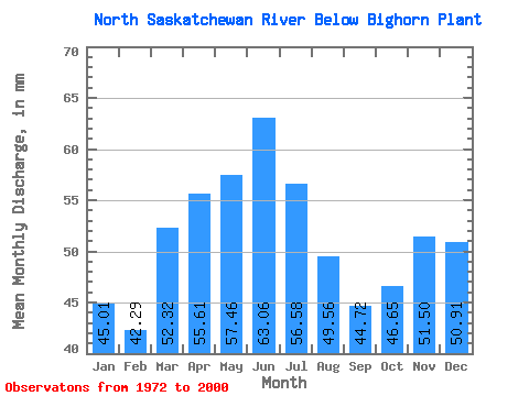
| Statistic | Jan | Feb | Mar | Apr | May | Jun | Jul | Aug | Sep | Oct | Nov | Dec | Annual |
|---|---|---|---|---|---|---|---|---|---|---|---|---|---|
| Mean | 45.00 | 42.66 | 52.31 | 55.61 | 57.45 | 63.06 | 56.57 | 49.55 | 44.72 | 46.64 | 51.50 | 50.91 | 619.83 |
| Standard Deviation | 8.64 | 11.24 | 11.03 | 12.24 | 16.95 | 16.52 | 22.02 | 20.22 | 16.41 | 13.73 | 10.13 | 11.31 | 70.15 |
| Min | 24.09 | 18.69 | 28.64 | 24.72 | 32.84 | 26.59 | 13.01 | 18.18 | 0.11 | 0.15 | 26.79 | 32.98 | 468.13 |
| Max | 57.76 | 65.23 | 73.66 | 80.62 | 100.51 | 103.28 | 105.33 | 93.63 | 76.63 | 77.10 | 69.96 | 70.22 | 803.81 |
| Coefficient of Variation | 0.19 | 0.26 | 0.21 | 0.22 | 0.29 | 0.26 | 0.39 | 0.41 | 0.37 | 0.29 | 0.20 | 0.22 | 0.11 |
 Return to R-Arctic Net Home Page