|
|
|||||||||||||||||
| Point ID: 455 | Downloads | Plots | Site Data | Code: 05DB005 |
|
|
|||||||||||||||||
| Download | |
|---|---|
| Site Descriptor Information | Site Time Series Data |
| Link to all available data | |
| View: | Time Series | All |
| Units: | mm |
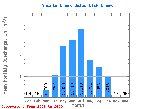
| Statistic | Jan | Feb | Mar | Apr | May | Jun | Jul | Aug | Sep | Oct | Nov | Dec | Annual |
|---|---|---|---|---|---|---|---|---|---|---|---|---|---|
| Mean | 0.37 | 1.05 | 2.42 | 2.71 | 3.21 | 1.79 | 1.45 | 1.02 | |||||
| Standard Deviation | 0.14 | 0.61 | 1.65 | 1.68 | 2.59 | 0.97 | 0.95 | 0.56 | |||||
| Min | 0.07 | 0.47 | 0.43 | 0.61 | 0.53 | 0.32 | 0.44 | 0.40 | |||||
| Max | 0.75 | 3.69 | 6.37 | 8.77 | 10.80 | 4.68 | 3.92 | 3.27 | |||||
| Coefficient of Variation | 0.37 | 0.58 | 0.68 | 0.62 | 0.81 | 0.54 | 0.65 | 0.55 |
 Return to R-Arctic Net Home Page