|
|
|||||||||||||||||
| Point ID: 455 | Downloads | Plots | Site Data | Code: 05DB005 |
|
|
|||||||||||||||||
| Download | |
|---|---|
| Site Descriptor Information | Site Time Series Data |
| Link to all available data | |
| View: | Time Series | All |
| Units: | m3/s |
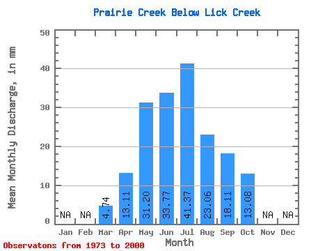
| Statistic | Jan | Feb | Mar | Apr | May | Jun | Jul | Aug | Sep | Oct | Nov | Dec | Annual |
|---|---|---|---|---|---|---|---|---|---|---|---|---|---|
| Mean | 4.74 | 13.11 | 31.20 | 33.77 | 41.37 | 23.06 | 18.11 | 13.08 | |||||
| Standard Deviation | 1.76 | 7.60 | 21.23 | 20.88 | 33.30 | 12.47 | 11.82 | 7.25 | |||||
| Min | 0.84 | 5.81 | 5.51 | 7.58 | 6.88 | 4.17 | 5.43 | 5.19 | |||||
| Max | 9.63 | 45.98 | 82.01 | 109.29 | 139.05 | 60.26 | 48.85 | 42.10 | |||||
| Coefficient of Variation | 0.37 | 0.58 | 0.68 | 0.62 | 0.81 | 0.54 | 0.65 | 0.55 |
 Return to R-Arctic Net Home Page