|
|
|||||||||||||||||
| Point ID: 450 | Downloads | Plots | Site Data | Code: 05DA010 |
|
|
|||||||||||||||||
| Download | |
|---|---|
| Site Descriptor Information | Site Time Series Data |
| Link to all available data | |
| View: | Time Series | All |
| Units: | mm |
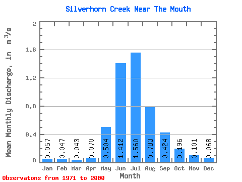
| Statistic | Jan | Feb | Mar | Apr | May | Jun | Jul | Aug | Sep | Oct | Nov | Dec | Annual |
|---|---|---|---|---|---|---|---|---|---|---|---|---|---|
| Mean | 0.06 | 0.05 | 0.04 | 0.07 | 0.50 | 1.41 | 1.56 | 0.78 | 0.42 | 0.20 | 0.10 | 0.07 | 0.44 |
| Standard Deviation | 0.01 | 0.01 | 0.02 | 0.04 | 0.26 | 0.44 | 0.57 | 0.22 | 0.15 | 0.07 | 0.03 | 0.02 | 0.07 |
| Min | 0.03 | 0.02 | 0.02 | 0.02 | 0.17 | 0.69 | 0.87 | 0.45 | 0.28 | 0.04 | 0.04 | 0.02 | 0.33 |
| Max | 0.10 | 0.07 | 0.10 | 0.17 | 1.23 | 2.40 | 2.77 | 1.40 | 0.86 | 0.45 | 0.16 | 0.11 | 0.63 |
| Coefficient of Variation | 0.27 | 0.23 | 0.43 | 0.57 | 0.52 | 0.31 | 0.37 | 0.28 | 0.35 | 0.36 | 0.27 | 0.29 | 0.17 |
 Return to R-Arctic Net Home Page