|
|
|||||||||||||||||
| Point ID: 450 | Downloads | Plots | Site Data | Code: 05DA010 |
|
|
|||||||||||||||||
| Download | |
|---|---|
| Site Descriptor Information | Site Time Series Data |
| Link to all available data | |
| View: | Time Series | All |
| Units: | m3/s |
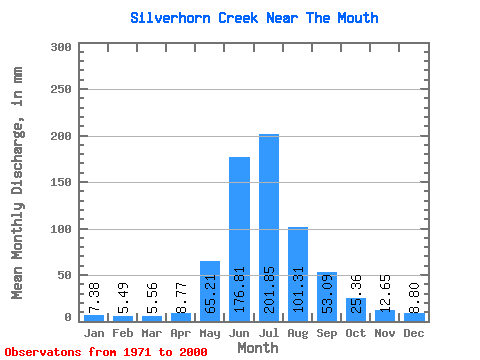
| Statistic | Jan | Feb | Mar | Apr | May | Jun | Jul | Aug | Sep | Oct | Nov | Dec | Annual |
|---|---|---|---|---|---|---|---|---|---|---|---|---|---|
| Mean | 7.33 | 5.49 | 5.57 | 8.76 | 65.24 | 176.87 | 201.78 | 101.29 | 53.14 | 25.39 | 12.60 | 8.78 | 666.32 |
| Standard Deviation | 1.97 | 1.28 | 2.41 | 4.99 | 33.62 | 55.00 | 73.97 | 28.66 | 18.82 | 9.25 | 3.43 | 2.59 | 110.53 |
| Min | 3.62 | 2.48 | 2.33 | 2.63 | 22.51 | 86.02 | 113.07 | 58.35 | 34.44 | 5.17 | 4.88 | 2.72 | 504.91 |
| Max | 12.29 | 8.72 | 12.68 | 21.54 | 159.13 | 300.52 | 358.36 | 181.12 | 107.94 | 57.96 | 20.54 | 14.49 | 958.87 |
| Coefficient of Variation | 0.27 | 0.23 | 0.43 | 0.57 | 0.52 | 0.31 | 0.37 | 0.28 | 0.35 | 0.36 | 0.27 | 0.29 | 0.17 |
 Return to R-Arctic Net Home Page