|
|
|||||||||||||||||
| Point ID: 449 | Downloads | Plots | Site Data | Code: 05DA009 |
|
|
|||||||||||||||||
| Download | |
|---|---|
| Site Descriptor Information | Site Time Series Data |
| Link to all available data | |
| View: | Time Series | All |
| Units: | mm |
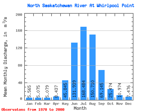
| Statistic | Jan | Feb | Mar | Apr | May | Jun | Jul | Aug | Sep | Oct | Nov | Dec | Annual |
|---|---|---|---|---|---|---|---|---|---|---|---|---|---|
| Mean | 5.56 | 5.08 | 5.08 | 8.44 | 45.84 | 131.94 | 168.48 | 150.71 | 69.14 | 25.47 | 10.97 | 7.48 | 52.82 |
| Standard Deviation | 0.84 | 0.68 | 0.62 | 2.59 | 20.14 | 29.31 | 26.25 | 29.11 | 17.43 | 7.13 | 2.54 | 1.30 | 5.26 |
| Min | 3.52 | 4.02 | 3.84 | 5.36 | 15.40 | 80.10 | 110.00 | 101.00 | 44.20 | 12.00 | 6.90 | 5.14 | 42.12 |
| Max | 7.27 | 6.72 | 6.37 | 17.40 | 93.10 | 198.00 | 214.00 | 205.00 | 102.00 | 51.10 | 17.40 | 10.90 | 64.58 |
| Coefficient of Variation | 0.15 | 0.14 | 0.12 | 0.31 | 0.44 | 0.22 | 0.16 | 0.19 | 0.25 | 0.28 | 0.23 | 0.17 | 0.10 |
 Return to R-Arctic Net Home Page