|
|
|||||||||||||||||
| Point ID: 449 | Downloads | Plots | Site Data | Code: 05DA009 |
|
|
|||||||||||||||||
| Download | |
|---|---|
| Site Descriptor Information | Site Time Series Data |
| Link to all available data | |
| View: | Time Series | All |
| Units: | m3/s |
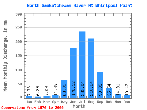
| Statistic | Jan | Feb | Mar | Apr | May | Jun | Jul | Aug | Sep | Oct | Nov | Dec | Annual |
|---|---|---|---|---|---|---|---|---|---|---|---|---|---|
| Mean | 7.76 | 6.45 | 7.08 | 11.39 | 63.94 | 178.12 | 235.00 | 210.21 | 93.35 | 35.53 | 14.81 | 10.43 | 868.23 |
| Standard Deviation | 1.17 | 0.87 | 0.86 | 3.49 | 28.10 | 39.57 | 36.61 | 40.61 | 23.53 | 9.95 | 3.43 | 1.82 | 86.50 |
| Min | 4.91 | 5.11 | 5.36 | 7.24 | 21.48 | 108.14 | 153.43 | 140.87 | 59.67 | 16.74 | 9.31 | 7.17 | 692.35 |
| Max | 10.14 | 8.54 | 8.88 | 23.49 | 129.85 | 267.30 | 298.49 | 285.93 | 137.70 | 71.27 | 23.49 | 15.20 | 1061.59 |
| Coefficient of Variation | 0.15 | 0.14 | 0.12 | 0.31 | 0.44 | 0.22 | 0.16 | 0.19 | 0.25 | 0.28 | 0.23 | 0.17 | 0.10 |
 Return to R-Arctic Net Home Page