|
|
|||||||||||||||||
| Point ID: 447 | Downloads | Plots | Site Data | Code: 05DA007 |
|
|
|||||||||||||||||
| Download | |
|---|---|
| Site Descriptor Information | Site Time Series Data |
| Link to all available data | |
| View: | Time Series | All |
| Units: | mm |
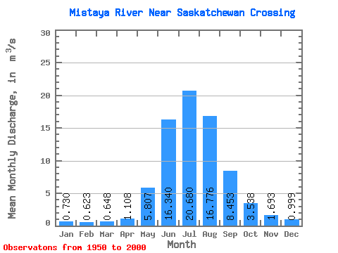
| Statistic | Jan | Feb | Mar | Apr | May | Jun | Jul | Aug | Sep | Oct | Nov | Dec | Annual |
|---|---|---|---|---|---|---|---|---|---|---|---|---|---|
| Mean | 0.73 | 0.62 | 0.65 | 1.11 | 5.81 | 16.34 | 20.68 | 16.78 | 8.45 | 3.54 | 1.69 | 1.00 | 6.36 |
| Standard Deviation | 0.11 | 0.12 | 0.16 | 0.43 | 2.32 | 3.62 | 2.98 | 2.78 | 2.17 | 1.13 | 0.43 | 0.18 | 0.57 |
| Min | 0.47 | 0.41 | 0.30 | 0.64 | 2.25 | 9.75 | 14.40 | 11.10 | 5.46 | 2.10 | 1.00 | 0.69 | 5.31 |
| Max | 0.94 | 0.88 | 0.98 | 2.31 | 11.90 | 25.50 | 25.60 | 24.40 | 14.40 | 7.35 | 2.65 | 1.53 | 7.96 |
| Coefficient of Variation | 0.15 | 0.20 | 0.24 | 0.39 | 0.40 | 0.22 | 0.14 | 0.17 | 0.26 | 0.32 | 0.26 | 0.19 | 0.09 |
 Return to R-Arctic Net Home Page