|
|
|||||||||||||||||
| Point ID: 447 | Downloads | Plots | Site Data | Code: 05DA007 |
|
|
|||||||||||||||||
| Download | |
|---|---|
| Site Descriptor Information | Site Time Series Data |
| Link to all available data | |
| View: | Time Series | All |
| Units: | m3/s |
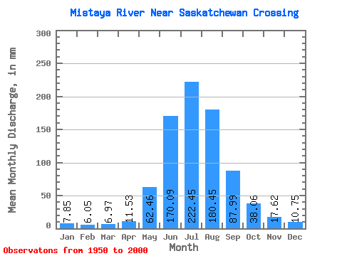
| Statistic | Jan | Feb | Mar | Apr | May | Jun | Jul | Aug | Sep | Oct | Nov | Dec | Annual |
|---|---|---|---|---|---|---|---|---|---|---|---|---|---|
| Mean | 7.85 | 6.11 | 6.97 | 11.54 | 62.45 | 170.09 | 222.41 | 180.43 | 87.99 | 38.05 | 17.63 | 10.74 | 805.62 |
| Standard Deviation | 1.20 | 1.19 | 1.70 | 4.48 | 24.93 | 37.65 | 32.06 | 29.93 | 22.62 | 12.12 | 4.53 | 2.00 | 72.46 |
| Min | 5.11 | 4.01 | 3.26 | 6.67 | 24.20 | 101.49 | 154.87 | 119.38 | 56.84 | 22.59 | 10.38 | 7.40 | 672.68 |
| Max | 10.09 | 8.62 | 10.53 | 24.05 | 127.98 | 265.45 | 275.33 | 262.42 | 149.90 | 79.05 | 27.59 | 16.45 | 1009.57 |
| Coefficient of Variation | 0.15 | 0.20 | 0.24 | 0.39 | 0.40 | 0.22 | 0.14 | 0.17 | 0.26 | 0.32 | 0.26 | 0.19 | 0.09 |
 Return to R-Arctic Net Home Page