|
|
|||||||||||||||||
| Point ID: 442 | Downloads | Plots | Site Data | Code: 05DA002 |
|
|
|||||||||||||||||
| Download | |
|---|---|
| Site Descriptor Information | Site Time Series Data |
| Link to all available data | |
| View: | Time Series | All |
| Units: | mm |
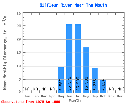
| Statistic | Jan | Feb | Mar | Apr | May | Jun | Jul | Aug | Sep | Oct | Nov | Dec | Annual |
|---|---|---|---|---|---|---|---|---|---|---|---|---|---|
| Mean | 9.57 | 25.58 | 25.50 | 16.93 | 9.29 | 4.62 | |||||||
| Standard Deviation | 3.87 | 5.53 | 6.83 | 3.87 | 1.92 | 0.77 | |||||||
| Min | 3.84 | 16.70 | 16.10 | 12.40 | 6.80 | 3.15 | |||||||
| Max | 17.70 | 37.40 | 43.80 | 28.10 | 14.90 | 5.82 | |||||||
| Coefficient of Variation | 0.40 | 0.22 | 0.27 | 0.23 | 0.21 | 0.17 |
 Return to R-Arctic Net Home Page