|
|
|||||||||||||||||
| Point ID: 442 | Downloads | Plots | Site Data | Code: 05DA002 |
|
|
|||||||||||||||||
| Download | |
|---|---|
| Site Descriptor Information | Site Time Series Data |
| Link to all available data | |
| View: | Time Series | All |
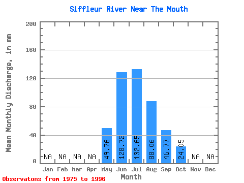
| Units: | m3/s |
| Statistic | Jan | Feb | Mar | Apr | May | Jun | Jul | Aug | Sep | Oct | Nov | Dec | Annual |
|---|---|---|---|---|---|---|---|---|---|---|---|---|---|
| Mean | 49.75 | 128.72 | 132.62 | 88.05 | 46.77 | 24.05 | |||||||
| Standard Deviation | 20.12 | 27.82 | 35.51 | 20.11 | 9.67 | 4.01 | |||||||
| Min | 19.97 | 84.05 | 83.72 | 64.48 | 34.22 | 16.38 | |||||||
| Max | 92.04 | 188.24 | 227.76 | 146.12 | 74.99 | 30.26 | |||||||
| Coefficient of Variation | 0.40 | 0.22 | 0.27 | 0.23 | 0.21 | 0.17 |
 Return to R-Arctic Net Home Page