|
|
|||||||||||||||||
| Point ID: 4401 | Downloads | Plots | Site Data | Code: 05PC016 |
|
|
|||||||||||||||||
| Download | |
|---|---|
| Site Descriptor Information | Site Time Series Data |
| Link to all available data | |
| View: | Time Series | All |
| Units: | mm |
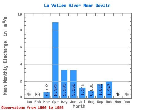
| Statistic | Jan | Feb | Mar | Apr | May | Jun | Jul | Aug | Sep | Oct | Nov | Dec | Annual |
|---|---|---|---|---|---|---|---|---|---|---|---|---|---|
| Mean | 0.70 | 8.92 | 3.31 | 3.26 | 1.25 | 0.83 | 1.61 | 1.95 | |||||
| Standard Deviation | 0.97 | 4.62 | 2.44 | 3.08 | 1.76 | 1.38 | 2.24 | 2.02 | |||||
| Min | 0.00 | 1.49 | 0.37 | 0.00 | 0.00 | 0.00 | 0.00 | 0.00 | |||||
| Max | 3.14 | 20.80 | 9.19 | 10.00 | 8.28 | 4.90 | 8.23 | 6.37 | |||||
| Coefficient of Variation | 1.38 | 0.52 | 0.74 | 0.94 | 1.41 | 1.66 | 1.39 | 1.04 |
 Return to R-Arctic Net Home Page