|
|
|||||||||||||||||
| Point ID: 4401 | Downloads | Plots | Site Data | Code: 05PC016 |
|
|
|||||||||||||||||
| Download | |
|---|---|
| Site Descriptor Information | Site Time Series Data |
| Link to all available data | |
| View: | Time Series | All |
| Units: | m3/s |
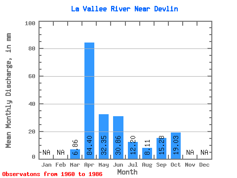
| Statistic | Jan | Feb | Mar | Apr | May | Jun | Jul | Aug | Sep | Oct | Nov | Dec | Annual |
|---|---|---|---|---|---|---|---|---|---|---|---|---|---|
| Mean | 6.86 | 84.40 | 32.34 | 30.86 | 12.20 | 8.11 | 15.28 | 19.03 | |||||
| Standard Deviation | 9.47 | 43.71 | 23.85 | 29.10 | 17.22 | 13.45 | 21.15 | 19.77 | |||||
| Min | 0.00 | 14.10 | 3.65 | 0.00 | 0.00 | 0.00 | 0.00 | 0.01 | |||||
| Max | 30.69 | 196.76 | 89.82 | 94.60 | 80.93 | 47.89 | 77.86 | 62.26 | |||||
| Coefficient of Variation | 1.38 | 0.52 | 0.74 | 0.94 | 1.41 | 1.66 | 1.39 | 1.04 |
 Return to R-Arctic Net Home Page