|
|
|||||||||||||||||
| Point ID: 4398 | Downloads | Plots | Site Data | Code: 05PC009 |
|
|
|||||||||||||||||
| Download | |
|---|---|
| Site Descriptor Information | Site Time Series Data |
| Link to all available data | |
| View: | Time Series | All |
| Units: | mm |
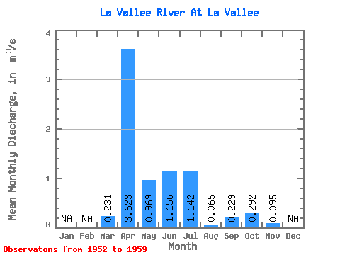
| Statistic | Jan | Feb | Mar | Apr | May | Jun | Jul | Aug | Sep | Oct | Nov | Dec | Annual |
|---|---|---|---|---|---|---|---|---|---|---|---|---|---|
| Mean | 0.23 | 3.62 | 0.97 | 1.16 | 1.14 | 0.07 | 0.23 | 0.29 | 0.10 | ||||
| Standard Deviation | 0.05 | 2.43 | 0.98 | 0.64 | 1.11 | 0.12 | 0.42 | 0.41 | |||||
| Min | 0.17 | 0.34 | 0.12 | 0.51 | 0.03 | 0.00 | 0.00 | 0.00 | 0.10 | ||||
| Max | 0.28 | 7.61 | 2.92 | 2.40 | 3.25 | 0.33 | 1.16 | 1.03 | 0.10 | ||||
| Coefficient of Variation | 0.23 | 0.67 | 1.01 | 0.55 | 0.97 | 1.86 | 1.84 | 1.39 |
 Return to R-Arctic Net Home Page