|
|
|||||||||||||||||
| Point ID: 4398 | Downloads | Plots | Site Data | Code: 05PC009 |
|
|
|||||||||||||||||
| Download | |
|---|---|
| Site Descriptor Information | Site Time Series Data |
| Link to all available data | |
| View: | Time Series | All |
| Units: | m3/s |
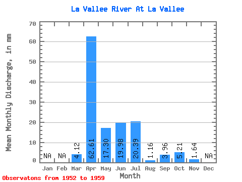
| Statistic | Jan | Feb | Mar | Apr | May | Jun | Jul | Aug | Sep | Oct | Nov | Dec | Annual |
|---|---|---|---|---|---|---|---|---|---|---|---|---|---|
| Mean | 4.12 | 62.60 | 17.31 | 19.98 | 20.39 | 1.15 | 3.95 | 5.21 | 1.64 | ||||
| Standard Deviation | 0.93 | 41.91 | 17.56 | 11.05 | 19.83 | 2.15 | 7.28 | 7.25 | |||||
| Min | 3.12 | 5.91 | 2.16 | 8.85 | 0.55 | 0.00 | 0.00 | 0.00 | 1.64 | ||||
| Max | 4.96 | 131.50 | 52.13 | 41.47 | 58.02 | 5.93 | 20.05 | 18.39 | 1.64 | ||||
| Coefficient of Variation | 0.23 | 0.67 | 1.01 | 0.55 | 0.97 | 1.86 | 1.84 | 1.39 |
 Return to R-Arctic Net Home Page