|
|
|||||||||||||||||
| Point ID: 4386 | Downloads | Plots | Site Data | Code: 05PA012 |
|
|
|||||||||||||||||
| Download | |
|---|---|
| Site Descriptor Information | Site Time Series Data |
| Link to all available data | |
| View: | Time Series | All |
| Units: | mm |
| Statistic | Jan | Feb | Mar | Apr | May | Jun | Jul | Aug | Sep | Oct | Nov | Dec | Annual |
|---|---|---|---|---|---|---|---|---|---|---|---|---|---|
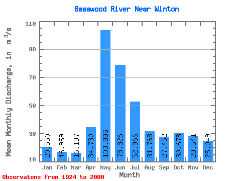
| Mean | 20.55 | 16.96 | 16.14 | 34.73 | 103.89 | 78.83 | 52.97 | 31.77 | 27.45 | 30.68 | 28.54 | 25.05 | 39.23 |
| Standard Deviation | 9.46 | 6.87 | 5.56 | 22.25 | 52.57 | 39.38 | 24.77 | 19.21 | 22.29 | 27.42 | 22.85 | 14.79 | 10.86 |
| Min | 2.44 | 2.69 | 3.82 | 7.62 | 6.36 | 14.50 | 14.50 | 7.88 | 3.41 | 1.84 | 1.70 | 2.16 | 18.88 |
| Max | 41.80 | 34.80 | 32.40 | 144.00 | 258.00 | 208.00 | 126.00 | 98.80 | 143.00 | 151.00 | 110.00 | 71.10 | 72.29 |
| Coefficient of Variation | 0.46 | 0.41 | 0.34 | 0.64 | 0.51 | 0.50 | 0.47 | 0.60 | 0.81 | 0.89 | 0.80 | 0.59 | 0.28 |
 Return to R-Arctic Net Home Page