|
|
|||||||||||||||||
| Point ID: 4386 | Downloads | Plots | Site Data | Code: 05PA012 |
|
|
|||||||||||||||||
| Download | |
|---|---|
| Site Descriptor Information | Site Time Series Data |
| Link to all available data | |
| View: | Time Series | All |
| Units: | m3/s |
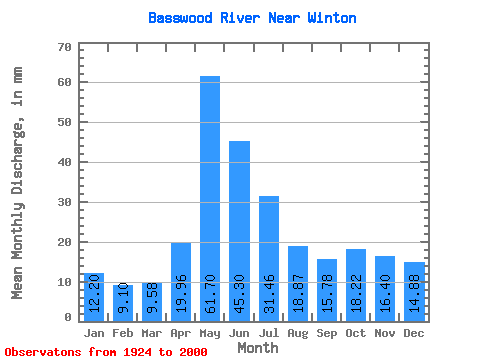
| Statistic | Jan | Feb | Mar | Apr | May | Jun | Jul | Aug | Sep | Oct | Nov | Dec | Annual |
|---|---|---|---|---|---|---|---|---|---|---|---|---|---|
| Mean | 12.20 | 9.18 | 9.58 | 19.96 | 61.69 | 45.30 | 31.45 | 18.86 | 15.78 | 18.22 | 16.40 | 14.87 | 274.52 |
| Standard Deviation | 5.62 | 3.72 | 3.30 | 12.79 | 31.21 | 22.63 | 14.71 | 11.40 | 12.81 | 16.28 | 13.13 | 8.78 | 75.99 |
| Min | 1.45 | 1.46 | 2.27 | 4.38 | 3.78 | 8.33 | 8.61 | 4.68 | 1.96 | 1.09 | 0.98 | 1.28 | 132.08 |
| Max | 24.82 | 18.83 | 19.24 | 82.76 | 153.20 | 119.54 | 74.82 | 58.67 | 82.19 | 89.66 | 63.22 | 42.22 | 505.88 |
| Coefficient of Variation | 0.46 | 0.41 | 0.34 | 0.64 | 0.51 | 0.50 | 0.47 | 0.60 | 0.81 | 0.89 | 0.80 | 0.59 | 0.28 |
 Return to R-Arctic Net Home Page