|
|
|||||||||||||||||
| Point ID: 4370 | Downloads | Plots | Site Data | Code: 04LJ001 |
|
|
|||||||||||||||||
| Download | |
|---|---|
| Site Descriptor Information | Site Time Series Data |
| Link to all available data | |
| View: | Time Series | All |
| Units: | mm |
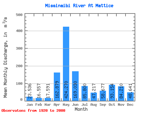
| Statistic | Jan | Feb | Mar | Apr | May | Jun | Jul | Aug | Sep | Oct | Nov | Dec | Annual |
|---|---|---|---|---|---|---|---|---|---|---|---|---|---|
| Mean | 23.54 | 16.56 | 17.59 | 162.88 | 424.27 | 169.03 | 85.80 | 47.22 | 58.68 | 93.15 | 84.21 | 48.64 | 102.99 |
| Standard Deviation | 8.21 | 5.26 | 10.97 | 106.94 | 169.14 | 78.44 | 51.69 | 25.50 | 50.45 | 67.72 | 44.21 | 25.23 | 22.99 |
| Min | 3.88 | 3.06 | 4.60 | 7.39 | 95.90 | 55.90 | 23.50 | 10.20 | 4.75 | 6.30 | 7.57 | 5.86 | 56.53 |
| Max | 45.30 | 32.00 | 62.90 | 408.00 | 824.00 | 498.00 | 307.00 | 118.00 | 227.00 | 264.00 | 182.00 | 115.00 | 181.83 |
| Coefficient of Variation | 0.35 | 0.32 | 0.62 | 0.66 | 0.40 | 0.46 | 0.60 | 0.54 | 0.86 | 0.73 | 0.53 | 0.52 | 0.22 |
 Return to R-Arctic Net Home Page