|
|
|||||||||||||||||
| Point ID: 4370 | Downloads | Plots | Site Data | Code: 04LJ001 |
|
|
|||||||||||||||||
| Download | |
|---|---|
| Site Descriptor Information | Site Time Series Data |
| Link to all available data | |
| View: | Time Series | All |
| Units: | m3/s |
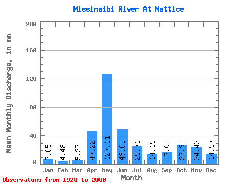
| Statistic | Jan | Feb | Mar | Apr | May | Jun | Jul | Aug | Sep | Oct | Nov | Dec | Annual |
|---|---|---|---|---|---|---|---|---|---|---|---|---|---|
| Mean | 7.05 | 4.52 | 5.27 | 47.22 | 127.09 | 49.01 | 25.70 | 14.14 | 17.01 | 27.91 | 24.41 | 14.57 | 363.57 |
| Standard Deviation | 2.46 | 1.44 | 3.29 | 31.01 | 50.66 | 22.74 | 15.48 | 7.64 | 14.63 | 20.29 | 12.82 | 7.56 | 81.17 |
| Min | 1.16 | 0.83 | 1.38 | 2.14 | 28.73 | 16.21 | 7.04 | 3.06 | 1.38 | 1.89 | 2.19 | 1.75 | 199.57 |
| Max | 13.57 | 8.73 | 18.84 | 118.29 | 246.83 | 144.39 | 91.96 | 35.35 | 65.81 | 79.08 | 52.77 | 34.45 | 641.91 |
| Coefficient of Variation | 0.35 | 0.32 | 0.62 | 0.66 | 0.40 | 0.46 | 0.60 | 0.54 | 0.86 | 0.73 | 0.53 | 0.52 | 0.22 |
 Return to R-Arctic Net Home Page