|
|
|||||||||||||||||
| Point ID: 4359 | Downloads | Plots | Site Data | Code: 04KA002 |
|
|
|||||||||||||||||
| Download | |
|---|---|
| Site Descriptor Information | Site Time Series Data |
| Link to all available data | |
| View: | Time Series | All |
| Units: | mm |
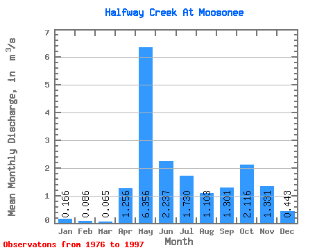
| Statistic | Jan | Feb | Mar | Apr | May | Jun | Jul | Aug | Sep | Oct | Nov | Dec | Annual |
|---|---|---|---|---|---|---|---|---|---|---|---|---|---|
| Mean | 0.17 | 0.09 | 0.07 | 1.26 | 6.36 | 2.24 | 1.73 | 1.10 | 1.30 | 2.12 | 1.33 | 0.44 | 1.54 |
| Standard Deviation | 0.13 | 0.05 | 0.03 | 1.03 | 2.28 | 1.00 | 1.61 | 1.12 | 0.99 | 1.18 | 0.70 | 0.25 | 0.44 |
| Min | 0.01 | 0.01 | 0.02 | 0.04 | 2.47 | 0.91 | 0.17 | 0.12 | 0.15 | 0.41 | 0.22 | 0.05 | 0.70 |
| Max | 0.43 | 0.20 | 0.13 | 3.33 | 12.30 | 4.68 | 6.31 | 5.23 | 4.65 | 5.96 | 2.86 | 0.91 | 2.17 |
| Coefficient of Variation | 0.76 | 0.63 | 0.49 | 0.82 | 0.36 | 0.45 | 0.93 | 1.02 | 0.76 | 0.56 | 0.52 | 0.56 | 0.29 |
 Return to R-Arctic Net Home Page