|
|
|||||||||||||||||
| Point ID: 4359 | Downloads | Plots | Site Data | Code: 04KA002 |
|
|
|||||||||||||||||
| Download | |
|---|---|
| Site Descriptor Information | Site Time Series Data |
| Link to all available data | |
| View: | Time Series | All |
| Units: | m3/s |
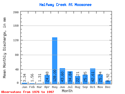
| Statistic | Jan | Feb | Mar | Apr | May | Jun | Jul | Aug | Sep | Oct | Nov | Dec | Annual |
|---|---|---|---|---|---|---|---|---|---|---|---|---|---|
| Mean | 3.35 | 1.59 | 1.31 | 24.49 | 127.98 | 43.60 | 34.84 | 22.20 | 25.36 | 42.60 | 25.95 | 8.91 | 366.21 |
| Standard Deviation | 2.55 | 0.99 | 0.64 | 19.99 | 45.82 | 19.58 | 32.41 | 22.65 | 19.31 | 23.70 | 13.57 | 5.03 | 104.60 |
| Min | 0.20 | 0.11 | 0.36 | 0.86 | 49.73 | 17.77 | 3.34 | 2.38 | 2.88 | 8.26 | 4.27 | 1.09 | 165.22 |
| Max | 8.68 | 3.72 | 2.56 | 64.90 | 247.66 | 91.21 | 127.05 | 105.31 | 90.62 | 120.01 | 55.74 | 18.34 | 513.72 |
| Coefficient of Variation | 0.76 | 0.63 | 0.49 | 0.82 | 0.36 | 0.45 | 0.93 | 1.02 | 0.76 | 0.56 | 0.52 | 0.56 | 0.29 |
 Return to R-Arctic Net Home Page