|
|
|||||||||||||||||
| Point ID: 4356 | Downloads | Plots | Site Data | Code: 04JF001 |
|
|
|||||||||||||||||
| Download | |
|---|---|
| Site Descriptor Information | Site Time Series Data |
| Link to all available data | |
| View: | Time Series | All |
| Units: | mm |
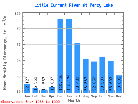
| Statistic | Jan | Feb | Mar | Apr | May | Jun | Jul | Aug | Sep | Oct | Nov | Dec | Annual |
|---|---|---|---|---|---|---|---|---|---|---|---|---|---|
| Mean | 22.13 | 16.96 | 14.54 | 18.01 | 110.50 | 110.17 | 78.49 | 56.87 | 52.86 | 59.40 | 53.60 | 33.80 | 51.53 |
| Standard Deviation | 7.33 | 5.07 | 3.41 | 6.54 | 36.02 | 54.19 | 33.02 | 34.30 | 36.65 | 35.07 | 25.87 | 13.06 | 15.59 |
| Min | 6.94 | 6.93 | 6.59 | 7.19 | 47.20 | 54.60 | 25.30 | 19.40 | 11.90 | 7.71 | 6.39 | 6.63 | 28.09 |
| Max | 33.90 | 23.90 | 19.60 | 37.00 | 194.00 | 279.00 | 147.00 | 144.00 | 178.00 | 143.00 | 116.00 | 59.00 | 85.73 |
| Coefficient of Variation | 0.33 | 0.30 | 0.23 | 0.36 | 0.33 | 0.49 | 0.42 | 0.60 | 0.69 | 0.59 | 0.48 | 0.39 | 0.30 |
 Return to R-Arctic Net Home Page