|
|
|||||||||||||||||
| Point ID: 4356 | Downloads | Plots | Site Data | Code: 04JF001 |
|
|
|||||||||||||||||
| Download | |
|---|---|
| Site Descriptor Information | Site Time Series Data |
| Link to all available data | |
| View: | Time Series | All |
| Units: | m3/s |
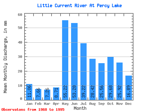
| Statistic | Jan | Feb | Mar | Apr | May | Jun | Jul | Aug | Sep | Oct | Nov | Dec | Annual |
|---|---|---|---|---|---|---|---|---|---|---|---|---|---|
| Mean | 11.05 | 7.72 | 7.26 | 8.71 | 55.21 | 53.28 | 39.22 | 28.41 | 25.56 | 29.68 | 25.92 | 16.89 | 303.44 |
| Standard Deviation | 3.66 | 2.31 | 1.70 | 3.16 | 18.00 | 26.21 | 16.50 | 17.14 | 17.72 | 17.52 | 12.51 | 6.53 | 91.80 |
| Min | 3.47 | 3.15 | 3.29 | 3.48 | 23.58 | 26.40 | 12.64 | 9.69 | 5.75 | 3.85 | 3.09 | 3.31 | 165.37 |
| Max | 16.94 | 10.88 | 9.79 | 17.89 | 96.93 | 134.92 | 73.44 | 71.95 | 86.08 | 71.45 | 56.10 | 29.48 | 504.80 |
| Coefficient of Variation | 0.33 | 0.30 | 0.23 | 0.36 | 0.33 | 0.49 | 0.42 | 0.60 | 0.69 | 0.59 | 0.48 | 0.39 | 0.30 |
 Return to R-Arctic Net Home Page