|
|
|||||||||||||||||
| Point ID: 4353 | Downloads | Plots | Site Data | Code: 04JD002 |
|
|
|||||||||||||||||
| Download | |
|---|---|
| Site Descriptor Information | Site Time Series Data |
| Link to all available data | |
| View: | Time Series | All |
| Units: | mm |
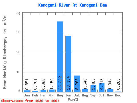
| Statistic | Jan | Feb | Mar | Apr | May | Jun | Jul | Aug | Sep | Oct | Nov | Dec | Annual |
|---|---|---|---|---|---|---|---|---|---|---|---|---|---|
| Mean | 0.85 | 0.70 | 0.97 | 1.15 | 35.32 | 28.19 | 8.26 | 1.65 | 3.49 | 4.71 | 1.34 | 0.28 | 7.27 |
| Standard Deviation | 5.52 | 4.25 | 4.67 | 4.27 | 48.26 | 36.24 | 16.36 | 5.44 | 12.94 | 20.72 | 4.42 | 0.87 | 8.87 |
| Min | 0.00 | 0.00 | 0.00 | 0.00 | 0.00 | 0.00 | 0.00 | 0.00 | 0.00 | 0.00 | 0.00 | 0.00 | 0.00 |
| Max | 41.00 | 31.50 | 26.70 | 21.80 | 216.00 | 144.00 | 90.40 | 33.00 | 76.40 | 149.00 | 21.40 | 4.36 | 47.68 |
| Coefficient of Variation | 6.49 | 6.07 | 4.83 | 3.71 | 1.37 | 1.28 | 1.98 | 3.30 | 3.71 | 4.40 | 3.29 | 3.05 | 1.22 |
 Return to R-Arctic Net Home Page