|
|
|||||||||||||||||
| Point ID: 4353 | Downloads | Plots | Site Data | Code: 04JD002 |
|
|
|||||||||||||||||
| Download | |
|---|---|
| Site Descriptor Information | Site Time Series Data |
| Link to all available data | |
| View: | Time Series | All |
| Units: | m3/s |
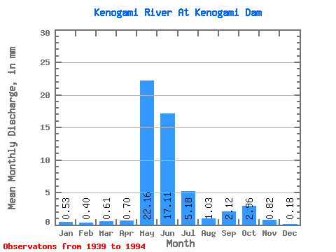
| Statistic | Jan | Feb | Mar | Apr | May | Jun | Jul | Aug | Sep | Oct | Nov | Dec | Annual |
|---|---|---|---|---|---|---|---|---|---|---|---|---|---|
| Mean | 0.53 | 0.40 | 0.61 | 0.70 | 22.15 | 17.11 | 5.18 | 1.03 | 2.12 | 2.96 | 0.82 | 0.18 | 53.74 |
| Standard Deviation | 3.46 | 2.43 | 2.93 | 2.59 | 30.27 | 22.00 | 10.26 | 3.41 | 7.86 | 13.00 | 2.68 | 0.54 | 65.52 |
| Min | 0.00 | 0.00 | 0.00 | 0.00 | 0.00 | 0.00 | 0.00 | 0.00 | 0.00 | 0.00 | 0.00 | 0.00 | 0.00 |
| Max | 25.71 | 18.00 | 16.75 | 13.23 | 135.47 | 87.41 | 56.70 | 20.70 | 46.38 | 93.45 | 12.99 | 2.73 | 352.41 |
| Coefficient of Variation | 6.49 | 6.07 | 4.83 | 3.71 | 1.37 | 1.28 | 1.98 | 3.30 | 3.71 | 4.40 | 3.29 | 3.05 | 1.22 |
 Return to R-Arctic Net Home Page