|
|
|||||||||||||||||
| Point ID: 4336 | Downloads | Plots | Site Data | Code: 04FB001 |
|
|
|||||||||||||||||
| Download | |
|---|---|
| Site Descriptor Information | Site Time Series Data |
| Link to all available data | |
| View: | Time Series | All |
| Units: | mm |
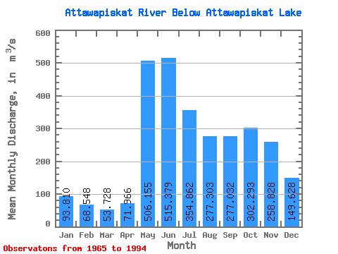
| Statistic | Jan | Feb | Mar | Apr | May | Jun | Jul | Aug | Sep | Oct | Nov | Dec | Annual |
|---|---|---|---|---|---|---|---|---|---|---|---|---|---|
| Mean | 93.81 | 68.55 | 53.73 | 71.97 | 506.15 | 515.38 | 354.86 | 277.30 | 277.03 | 302.29 | 258.83 | 149.63 | 245.32 |
| Standard Deviation | 24.25 | 15.63 | 11.60 | 38.73 | 245.55 | 291.35 | 178.82 | 140.21 | 166.66 | 159.39 | 119.99 | 52.72 | 80.31 |
| Min | 54.10 | 39.60 | 25.20 | 17.70 | 98.50 | 121.00 | 124.00 | 92.80 | 67.90 | 82.20 | 117.00 | 76.90 | 118.58 |
| Max | 151.00 | 97.00 | 82.40 | 242.00 | 1170.00 | 1340.00 | 915.00 | 604.00 | 681.00 | 664.00 | 514.00 | 275.00 | 389.62 |
| Coefficient of Variation | 0.26 | 0.23 | 0.22 | 0.54 | 0.48 | 0.56 | 0.50 | 0.51 | 0.60 | 0.53 | 0.46 | 0.35 | 0.33 |
 Return to R-Arctic Net Home Page