|
|
|||||||||||||||||
| Point ID: 4336 | Downloads | Plots | Site Data | Code: 04FB001 |
|
|
|||||||||||||||||
| Download | |
|---|---|
| Site Descriptor Information | Site Time Series Data |
| Link to all available data | |
| View: | Time Series | All |
| Units: | m3/s |
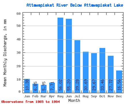
| Statistic | Jan | Feb | Mar | Apr | May | Jun | Jul | Aug | Sep | Oct | Nov | Dec | Annual |
|---|---|---|---|---|---|---|---|---|---|---|---|---|---|
| Mean | 10.38 | 6.91 | 5.95 | 7.71 | 56.01 | 55.20 | 39.27 | 30.69 | 29.67 | 33.45 | 27.72 | 16.56 | 319.93 |
| Standard Deviation | 2.68 | 1.58 | 1.28 | 4.15 | 27.17 | 31.20 | 19.79 | 15.52 | 17.85 | 17.64 | 12.85 | 5.83 | 104.73 |
| Min | 5.99 | 3.99 | 2.79 | 1.90 | 10.90 | 12.96 | 13.72 | 10.27 | 7.27 | 9.10 | 12.53 | 8.51 | 154.65 |
| Max | 16.71 | 9.78 | 9.12 | 25.92 | 129.47 | 143.52 | 101.25 | 66.84 | 72.94 | 73.48 | 55.05 | 30.43 | 508.11 |
| Coefficient of Variation | 0.26 | 0.23 | 0.22 | 0.54 | 0.48 | 0.56 | 0.50 | 0.51 | 0.60 | 0.53 | 0.46 | 0.35 | 0.33 |
 Return to R-Arctic Net Home Page