|
|
|||||||||||||||||
| Point ID: 391 | Downloads | Plots | Site Data | Code: 05CE006 |
|
|
|||||||||||||||||
| Download | |
|---|---|
| Site Descriptor Information | Site Time Series Data |
| Link to all available data | |
| View: | Time Series | All |
| Units: | mm |
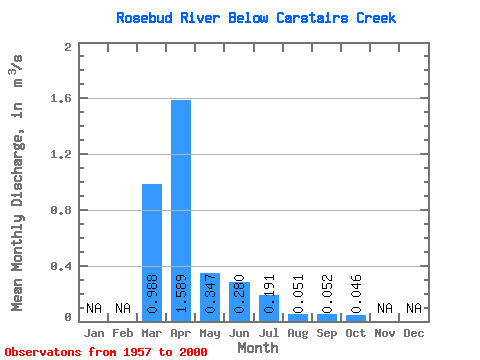
| Statistic | Jan | Feb | Mar | Apr | May | Jun | Jul | Aug | Sep | Oct | Nov | Dec | Annual |
|---|---|---|---|---|---|---|---|---|---|---|---|---|---|
| Mean | 0.99 | 1.59 | 0.35 | 0.28 | 0.19 | 0.05 | 0.05 | 0.05 | |||||
| Standard Deviation | 1.48 | 2.79 | 0.57 | 0.49 | 0.29 | 0.09 | 0.12 | 0.14 | |||||
| Min | 0.00 | 0.02 | 0.00 | 0.00 | 0.00 | 0.00 | 0.00 | 0.00 | |||||
| Max | 6.36 | 10.80 | 2.64 | 2.55 | 1.43 | 0.51 | 0.53 | 0.91 | |||||
| Coefficient of Variation | 1.50 | 1.76 | 1.65 | 1.76 | 1.51 | 1.80 | 2.23 | 3.06 |
 Return to R-Arctic Net Home Page