|
|
|||||||||||||||||
| Point ID: 378 | Downloads | Plots | Site Data | Code: 05CC010 |
|
|
|||||||||||||||||
| Download | |
|---|---|
| Site Descriptor Information | Site Time Series Data |
| Link to all available data | |
| View: | Time Series | All |
| Units: | mm |
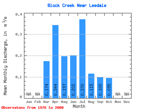
| Statistic | Jan | Feb | Mar | Apr | May | Jun | Jul | Aug | Sep | Oct | Nov | Dec | Annual |
|---|---|---|---|---|---|---|---|---|---|---|---|---|---|
| Mean | 0.17 | 0.34 | 0.20 | 0.20 | 0.37 | 0.12 | 0.10 | 0.10 | |||||
| Standard Deviation | 0.13 | 0.23 | 0.14 | 0.16 | 0.36 | 0.08 | 0.05 | 0.06 | |||||
| Min | 0.00 | 0.08 | 0.04 | 0.04 | 0.00 | 0.01 | 0.02 | 0.03 | |||||
| Max | 0.57 | 1.03 | 0.56 | 0.55 | 1.30 | 0.34 | 0.25 | 0.29 | |||||
| Coefficient of Variation | 0.75 | 0.67 | 0.70 | 0.77 | 0.98 | 0.70 | 0.54 | 0.58 |
 Return to R-Arctic Net Home Page