|
|
|||||||||||||||||
| Point ID: 378 | Downloads | Plots | Site Data | Code: 05CC010 |
|
|
|||||||||||||||||
| Download | |
|---|---|
| Site Descriptor Information | Site Time Series Data |
| Link to all available data | |
| View: | Time Series | All |
| Units: | m3/s |
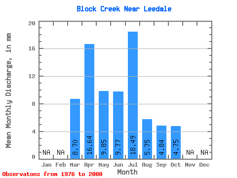
| Statistic | Jan | Feb | Mar | Apr | May | Jun | Jul | Aug | Sep | Oct | Nov | Dec | Annual |
|---|---|---|---|---|---|---|---|---|---|---|---|---|---|
| Mean | 8.70 | 16.65 | 9.84 | 9.75 | 18.49 | 5.72 | 4.84 | 4.74 | |||||
| Standard Deviation | 6.49 | 11.15 | 6.92 | 7.54 | 18.21 | 4.00 | 2.60 | 2.77 | |||||
| Min | 0.00 | 3.72 | 2.15 | 1.98 | 0.10 | 0.35 | 0.87 | 1.30 | |||||
| Max | 28.43 | 49.82 | 27.93 | 26.46 | 64.96 | 16.89 | 12.04 | 14.29 | |||||
| Coefficient of Variation | 0.75 | 0.67 | 0.70 | 0.77 | 0.98 | 0.70 | 0.54 | 0.58 |
 Return to R-Arctic Net Home Page